
1 - Activities/Fishing
School of Aquatic and Fishery Sciences
Bush Point Rod & Reel
WA Department of Fish and Wildlife
Red Tide Information
WA State Fisheries - Shellfish Toxin Hotline # is 1-800-562-5632.
2 - NEW: Washington State Department of Health - Shellfish Safety Information Interactive Map:
Washington State Department of Health's Shellfish Safety Map
3 - Oyster Testing Results:
2024 OYSTER TESTS: Our first test of the year on July 9th were ALL CLEAR.
Results are below.
July 2024
October 2023:
Email from: Washington State Department of Health:
There are several things that go into upgrading an all species biotoxin closure. You need at least two (sometimes 4 or more …) good results below the action level before upgrading. We look at the surrounding area and if toxin persists in the general area the closure will remain. Our biotoxin program also looks at phytoplankton monitoring. If harmful algal cells are still present the closure will continue. Also, we work with the local county health department and time the upgrade when county staff have time to change out the closure signs and do a news release. In your area the west side of Whidbey Island will be upgraded tomorrow. Give me a call if you have additional questions.
Chuck Hammer runs the oyster testing program along with the help of Lagoon Point resident volunteers. Please contact Chuck to pick your date to volunteer. Chuck's email: capthammer@cablespeed.com
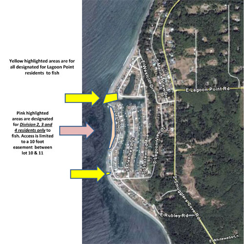
4 - MEMBERS FISHING MAP:
5 - RULES FOR USE OF LPCA COMMON PROPERTIES:
Use of LPCA Common Properties* are open to all Members, their families and guests as well as long term renters who have a rental agreement with a Member that is for a term of not less than six (6) months. LPCA Members are responsible for the actions of their guests and assume all liability for any and all injury or damage to any persons or property by the actions of their guests and indemnify LPCA against any and all claims and or losses. LPCA Members must accompany their guests at all times while on LPCA property. All others may be prosecuted for trespassing. (RCW 9A.52.080)
Cards and Tags may be obtained from the “Gate Card Administrator” See “Contact Us” for current Administrator.
*Description of LPCA Common Properties can be found at lagoonpoint.com, tab Docs & Maps”, “Guide to Common Properties”.
6 - PARKING TAGS, FISHING TAGS AND LOT C GATE CARD
A. To access parking, fishing on the beach and boat ramp, Members must have a Parking Tag, Fishing Tag and Lot C Gate Card.
1. Tags and Gate Card are the property of LPCA. Use is subject to the terms and conditions of the “Lot C Gate Card, Fishing and Parking Tag Policy” and will be deactivated if the policy is violated. The policy is located on the “Docs and Maps” tab under “LPCA Policies”.
2. Tags and Gate Card SHALL NOT be loaned to any person who is not a LPCA Member or who is renting a Member’s property for less than six (6) months.
3. When using parking lots or the boat ramp, the Parking Tag must be visible in or on your vehicle. Vehicles without a visible Parking Tag are subject to penalties for trespassing and or towing.
4. When fishing from the Lot C or Lot D Community Beach, your Fishing Tag shall be visibly carried on your person.
5. Tags do not permit access to privately owned beach lands. 6. In order to obtain Tags and Gate Cards see “Lot C Gate Card, Fishing and Parking Tag Policy” under tab “Docs & Maps”, “LPCA Policies”.
6. In order to obtain Tags and Gate Cards see “Lot C Gate Card, Fishing and Parking Tag Policy” under tab “Docs & Maps”, “LPCA Policies”.
7 - BOAT LAUNCH (LOT C) GATE OPERATION:
A. Opening and Closing the Boat Launch (Lot C) Gate:
1. The card scanners on each side of the gate are proximity scanners.
2. Wave the Gate Card within 4 inches and the gate will open and stay open for about 1 minute.
3. It is recommended that you drive your vehicle and boat trailer completely through the gate when entering or exiting the parking lot.
4. There are ground sensors on each side of the gate which should stop the gate from closing while you are in the process of entering or exiting.
5. There is also a pressure sensor that should stop and reverse the gate if it comes in contact with a hard object. It is a black rubber strip on the gate edge.
B. Power Issues:
1. If the gate controller loses power, it will remain in position where it was at the time of the power loss.
2. If this happens, the gate can be opened by hand by pushing the gate back towards the power pole. (This is a heavy gate therefore not easy.)
3. Leave the gate in the open position for others to get in or out. When power is restored the gate will go through a series of open and close cycles to re-calibrate.
C. Emergencies:
In case of emergencies, the Fire or Emergency Department has a key to the “Knock Box” mounted on the front of the gate that will override and open the gate. The gate will remain open until the Fire or Emergency Department switches it back on.
Boat Launch (Lot C) Gate Problems:
Please report gate problems to one of the gate committee members
listed below:
Dick Kuss by email: dick.kuss@lpcawa.org
Carl Haslam by email: Waterway@lpcawa.org
Rob Powers by email: rob@rdpowerssalvage.com
Chris Akker by email: cakker@hotmail.com
8 - PARKING AT LOT C & LOT B
A. No camping.
B. No storing vehicles, trailers and or boats. They will be subject to being towed.
C. Overnight parking in Lot C is allowed for a vehicle with boat trailer exclusively for those Members who are out on their boat overnight. Members leaving a vehicle and trailer overnight should park well away from the boat ramp. Vehicles or trailers being stored overnight for other reasons are subject to being towed.
9 - DOCK AND BOAT RAMP RULES:
A. The primary purpose of the Lot C dock and boat ramp is for launching and retrieving vessels.
1. Members fishing from the dock must move and allow approaching vessel priority use of the dock and boat ramp.
2. The boat launch and dock are for launching and retrieving vessels. Short and long term moorage is not allowed.
3. Members may use the boat ramp for launching and retrieving private docks and pilings after obtaining a special use permit from the LPCA Board of Directors. See “Special Use Policy, Application and Permit/ Contract for use of Lot B and Lot C parking lots and launch ramp for Private Dock or Piling Project” located on the Docs/Maps tab, “LPCA Policies”.
4. No parking in front of boat launch. Keep area clear for vehicles with
trailers to maneuver for launching and retrieving vessels.
10 - JETTY:
All residents must be aware that to climb on or fish from the jetty rocks is extremely dangerous (jetty rocks can and do move). Any persons who climbs on or fishes from them, do so at their own risk. All residents are requested to discourage others from doing so.
11 - WATERWAY RULES:
A. TRAFFIC SAFETY ON THE LAGOON POINT WATERWAY:
All vessels including kayaks and paddle boards operating within the Lagoon Point waterway are governed by the “International Regulations for Preventing Collisions at Sea” known as COLREGS 72* otherwise known as “The Rules of the Road”. It is the obligation of the person in command of a vessel to understand and comply with COLREGS 72 -International that apply to all Puget Sound.
*COLREGS 72 “International Rules” (not Inland Rules) apply to Puget sound and may be found at this link: www.navcen.uscg.gov/pdf/navrules/navrules.pdf
12 - B. RIGHT OF WAY IN THE JETTY CHANNEL:
The jetty channel is narrow and requires knowledge of existing conditions as well as attention to other vessels than may be attempting to transit. Vessels attempting to enter into the jetty channel from the west should pass far enough to the north to view any potential oncoming vessels. Vessels entering from either side shall sound their horn for 4-6 seconds and listen for a response before entering the channel. Personal watercraft shall make way for larger boats that require deeper draft.
COLREGS:
Rule 9 (narrow channels) (f) “A vessel nearing a bend or an area of narrow channel or fairway where other vessels may be obscured by an intervening obstruction shall navigate with particular alertness and caution and shall sound the appropriate signal prescribed in Rule 34 (e)”.
Rule 34 (e) “A vessel nearing a bend or an area of a channel or fairway where other vessels may be obscured by an intervening obstruction shall sound one prolonged blast”.
Rule 32 (c) “The term "prolonged blast" means a blast from four to six seconds duration”.
Rule 9 (d) “A vessel shall not cross a narrow channel or fairway if such crossing impedes the passage of a vessel which can safely navigate only within that channel or fairway”.
13 - C. FISHING FROM A VESSEL:
Some boaters mistakenly believe that a vessel engaged in fishing has the right of way. COLREG Rule 3 (d) makes it clear that a sport-fishing or trolling boat does not qualify as “a vessel engaged in fishing”.
In addition, COLREG Rule 9 (c) states: “A vessel engaged in fishing shall not impede the passage of any other vessel navigating within a narrow channel or fairway”.
14 - D. CHANNEL DEPTH:
Depth at the Jetty channel entrance changes frequently as sand bars come and go. Transiting the channel without current knowledge of the channel configuration can be hazardous especially if you are pushing the limits of your draft. A frequent inspection of the entrance at low tide is highly recommended.
15 - E. NO WAKE ZONE:
The LPCA waterway is a “no wake” zone and the person in command may be held legally responsible for damage to boats, docks and other vessels cause by their wake. Wake also accelerates erosion to the shoreline and may increase the frequency of dredging. Please watch your wake!
16 - F. CRAB POTS:
Crab pots can present a hazard to navigation. State regulations require the use of sinking buoy lines for crab pots inside the entrance from Admiralty Inlet. Lines can foul props and rudders resulting in loss of propulsion and or steerage.
1. Crab pots may only be set in the northeast portion of the LPCA waterway near the bridge. Pots set in that area shall not obstruct boat traffic to and from the east canal creating a hazard to navigation.
2. Crab pots shall not be set in the jetty channel, the boat dock or any part of Lot C except the northeast portion.
3. Crab pots shall not be set in the private east or west canals except from owner’s docks so as not to obstruct the right of way and create a hazard to navigation.
17 - G. DIVISION 2-3-4 PRIVATE EAST AND WEST CANALS:
The east and west canals are not part of the LPCA “Common Properties” however as a navigable waterway the canals are accessible to all Members.
All boats moored on their property in the private canals are encouraged to have a clearly displayed identification sticker with the owner's name, current address and phone number for notification in an emergency, e.g. sinking due to a storm or equipment failure.
Revised June 17th, 2021
Background image credit: Hugh Shipman - Gravel Beach © 2019 Lagoon Point. All Rights Reserved.